On Tuesday the 4th of August a massive explosion took place in Beirut, Lebanon. The death toll is already at 137 and just two days later hundreds of people are still missing and even more have been displaced.
Discover our latest podcast
Recent figures state that the explosion wounded over 5,000 people and hundreds are still missing, sparking fears that the death toll will soon rise even further. Hospitals in the capital have also been undergoing hardship as beds were already filling up due to the coronavirus leaving little space for those injured. Several hospitals were also too damaged by the explosion to be able to take on any new patients.

The country has also declared a two-week state of emergency after the deadly explosion tore much of the city apart and has left 300,000 people displaced as their homes have been destroyed.
It is still unclear what caused the explosion but an investigation is underway to examine the 2,750 metric tons of ammonium nitrate that was being stored in a warehouse in the area since 2014. Many people's fear has turned to anger as there were many warnings given to the Lebanese capital about the danger of storing the extremely explosive and highly deadly chemicals.

Many believe that blast could be attributed to government negligence in the already corrupt country as many documents, emails and court noticed have been unearthed that show officials knew about the chemical stockpile once described as a 'floating bomb'.
One person uploaded a video of the explosion to Twitter and made a very poignant statement in the comments about the already struggling country. The poster stated:
FYI - this comes at one of the worst time in Lebanon's history, a deep economic crisis with more and more of the population unable to access food, health care. The general mood was that it can't get worse. #Beirut.
She continued in another comment:
Hospitals in #Lebanon are overwhelmed because of #COVID_19 and lack of funding. We've seen massive layoffs recently, increasing strain. Red Cross reporting hundreds injured #Beirut
A video I received on WhatsApp of the scalr of explosion in #Beirut, confirming it was at the port. pic.twitter.com/bIkcyfsi0o
— Bissan Fakih (@BissanCampaigns) August 4, 2020
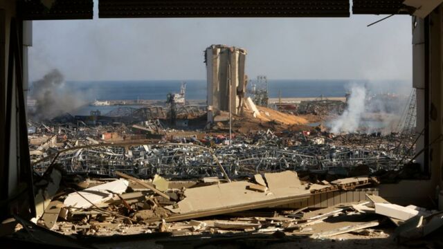
Photos have been released that show the devastating effects of the blast and even reveal the massive crater left in the port. The first image was taken on the 31st of May.

The image of the port after the explosion shows a massive crater dug into the side and buildings nearby completely destroyed. The image was taken on the 5th of August, the sea also looks eerily still compared to the first image.

Professor Andy Tyas from the Unoversity of Sheffield told BBC News:
Whatever the precise charge size, this is unquestionably one of the largest non-nuclear explosions in history, far bigger than any conventional weapon.
He continued:
We have also analysed video footage of the time delay between the detonation and the arrival of the shock wave at points several hundred metres from the explosion and these broadly agree with this size of charge. If correct, that would mean this explosion had perhaps 10% of the intensity of the Hiroshima bomb.

To compare the size and state of the devastation, professional cartographer, Joanna Merson created some shocking images that show the scale of the effects of the explosion by comparing it to both London and Manhattan.
Merson created the graphics after seeing someone else's incorrect depictions. She stated:
This morning I woke up to see viral maps incorrectly comparing the damage area of the Beirut explosion to London and New York. I have corrected the maps with a little thread to explain my corrections.
First, Merson created a graphic to display the 10km radius of damage from the explosion.

She continued:
A curious and well intentioned person used an online tool that slaps circles onto google maps, but none of the maps show any distances or scale. And the google maps are, of course, projected in Web Mercator, which does NOT show distance equally across different latitudes.
I picked the 10km radius by measuring the distance to the airport runways in the original map. The circles ignore all topography, while it looks like the actual damage stretched farther along the coastline and not as far inland, uphill(?).
Then, to compare she overlayed the same blast site radius onto London:

And then onto Manhattan:


